

A customized Google Maps program could save lives and help prevent millions—even billions—of dollars in flood damage to the world’s largest medical center and its surrounding communities after Rice University researchers upgraded the school’s flood-tracking technology this summer.
Created in 1997, the university’s online Flood Alert System (FAS) has seen three iterations, with the latest involving software that can show the potential depth of flood waters in the detailed Google Maps format.
The newest system, known as FAS3, allows anyone—including Rice students working on the project—to track how much flooding will occur in the Houston area in the next 60-90 minutes, according to Rice’s Severe Storm Prediction, Education, and Evacuation from Disasters Center (SSPEED).
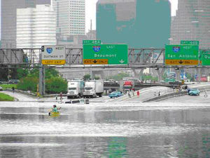
That hour-and-a-half warning proved critical in June 2001, when a tropical storm dumped 28 inches of rain on the Houston region in 12 hours, killing 22 people, stranding 30,000, and causing $5 billion in property damage, including $2 billion in damages at the sprawling Texas Medical Center.
Rice’s warning system gave the 46-million-square-foot, 6,000-bed medical center 90 minutes to evacuate employees and patients who would have been vulnerable to the extreme flooding. The federal government pumped $300,000 into Rice’s alert system after the 2001 flood—caused by Tropical Storm Allison—and SSPEED receives funding from the medical center every year.
More than $1.3 million has been invested in the Flood Alert System since its inception.
Phil Bedient, a Rice engineering professor and director of SSPEED, said the revamped flood warning system tracks real-time traffic patterns and water levels near the local State Highway 288 bridge, a much-used evacuation route during torrential downpours or flooding.
Using Google Maps, Bedient said, makes the new tool accessible to web users, and the addition of a topographic program that uses light detection appeals to researchers who want in-depth floodplain information.
“It’s a wonderful educational tool … and students are drawn to it,” he said, adding that students from the undergraduate to the Ph.D. level have helped Rice University researchers develop FAS. “It’s very graphical, very visual, and it reinforces what they’re learning in the classroom.”
Rice researchers were going to develop new floodplain mapping software for the third version of the flood alert system, but the quick development and ubiquity of Google Maps drew their attention.
When Bedient realized the Google maps technology “was completely there”—ready for use beyond getting directions to the mall—SSPEED officials made the web-based application the centerpiece of the university’s updated alert system.
“The more we watched Google Maps explode on the horizon and in general daily use, the more we wanted to use it,” he said.
Not every update to the new alert system is visible to the average web site visitor. The latest alert system version “contains improvements under the hood, which users won’t see directly,” such as XML technology that refreshes the FAS3 web page every few minutes, said Jerry Fowler, a Rice University computer science graduate who has worked with SSPEED officials since 2001.
The Flood Alert System has predicted flooding for 40 major storms in its 12 years of operation, according to SSPEED, including notable events like Tropical Storm Frances in 1998 and Hurricane Ike in 2008. The system was last updated in 2004, when radar was incorporated.
Rice’s alert technology has always focused on Brays Bayou, a 127-square-mile watershed that drains in parts of Houston and six nearby suburbs, according to SSPEED, and the Texas Medical Center’s 140 buildings and 93,000 employees have always been vulnerable to flooding from the watershed.
Flood season technically starts June 1, Bedient said, but most major flooding doesn’t threaten the Houston area until August, September, and October. He said SSPEED researchers track weather patterns closely in the late summer and fall, but it takes “quite a lot of rainfall” to grab their attention.
“We have to get six inches of rain to get excited about flood opportunities,” Bedient said. “We start to look at it very carefully at that point.”
- Research: Social media has negative impact on academic performance - April 2, 2020
- Number 1: Social media has negative impact on academic performance - December 31, 2014
- 6 reasons campus networks must change - September 30, 2014