Gone are the days of the static campus map. Today, campuses of all size and type—from massive public universities to prep schools and urban city colleges—are integrating real-time data feeds into their campus maps.
As the internet of things (IoT) continues to heat up and more campus departments and technologies are connected, I anticipate seeing a lot more of these integrations down the road.
Below are several exciting applications that can integrate into a campus map platform, mobile apps, and other areas to make it easier for students, staff, faculty, and visitors.
1. Real-time parking lot occupancy
Providing your college’s visitors with live parking feeds is an incredibly helpful tool. Finding parking is not only a frustration for the driver, but it also causes congestion and unnecessary pollution on campus. With live parking lot feeds, visitors can easily see which lots are full as well as those filling up and wide open—as they approach campus.
Live parking feeds are also incredibly helpful for event-day and construction staff directing traffic and parking. Arizona State University has integrated real-time parking lot occupancy data into its campus map. By looking at the feed, visitors can see the status of a specific parking lot and make a split-second decision. The lots are color coded: green for low occupancy, yellow for filling up, and red for full.
Live parking data integration gives admissions, marketing, and facilities officials the ability to redirect visitors on-the-fly and also to indicate when a particular lot is closed for a special event or construction, among other uses. Map visitors can select a specific lot to see the exact number of spaces available and anyone with a mobile device can head to the campus map and immediately see available parking.
2. Transit
Because of limited parking, many campuses encourage the use of public or mass transit. In partnership with Ride Systems, a technology company, real-time transit feeds can be integrated into the campus map. The system uses GPS tracking to provide users with the ability to view bus/shuttle routes, see the exact location of buses, and estimated times of arrival.
Rice University in Texas was one of the first to use the live transit feature on its interactive campus map. Riders love having real-time bus information and routes easily accessible on mobile devices.
3. Campus events feed and calendar
Getting the word out about on-campus events can be challenging. Integrating a live event feed into your map allows users to see what’s happening where and when. Whether it’s commencement, a guest lecturer, sporting events, or a musical, students can find details about (and the route to) campus events with ease.
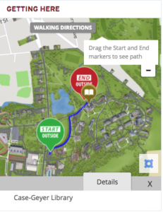
Going high tech, campus map sections can be included within a separate calendar or event feed web page. For example, we integrated with Localist, an online calendar platform, so campuses could include a detailed, 3D representation of a specific area of campus right in the event feed. This allows staff and students to get all the details about the event as well as where it is taking place in one location.
See how a small section of the map is used to highlight events at Colgate University’s Case-Geyer Library.
Rice University provides a campus events feed within its map that is updated nightly for a quick snapshot of campus-wide events.
4. Live campus cameras
How long is the Starbucks line? Answering that question at Ole Miss is easy, thanks to a live camera feed accessible through the university’s interactive map. Live camera feeds provide a host of benefits to a variety of map users. Ole Miss incorporates the technology into its interactive campus map to provide students, prospective students, visitors, faculty, and staff with real-time video of certain areas of the campus. There are several live cameras positioned at coffee shops and grab-and-go restaurants that allow map users to see how long the lines are. The map also includes several outdoor cameras—a great way for people to quickly check the weather or see how crowded an area is. Additionally, Ole Miss has live cameras that provide video of the on-campus construction that is taking place.
The combination of the live cameras provides a quick glance at on-campus life and can be a great tool for prospective students to get a feel for the general vibe of the campus.
5. ESRI data integration
Campus facilities professionals typically uses ESRI’s ArcGIS, a leading mapping and spatial analytics software. According to ESRI, more than 75 percent of Fortune 500 companies use the software for their GIS (geography information systems) needs. The maps and analytics that ArcGIS yields are extraordinarily complex and detailed, which is why their use tends to be heavily catered to specific fields or tasks. For example, geographers or professionals involved in facilities management benefit greatly from ArcGIS software because their maps offer so much detail, such as the smallest cracks in a sidewalk.
However, by integrating specific data feeds into an outward-facing map, facilities professionals can share select data with the entire campus or use it to show planned changes, campus maintenance needs, and other information to other departments.
No matter how you choose to integrate high-tech features and data, your campus map users will appreciate the real time and dynamic data available. In this day and age, real-time information is pertinent and it will make your map a more relevant and frequently visited site for reliable live updates and info regarding campus happenings. The opportunities for data integration into digital campus maps are endless.
- Survey: More students want to go to graduate school - April 24, 2024
- Educause, AWS launch generative AI readiness assessment tool for higher ed - April 23, 2024
- A bungled FAFSA rollout threatens students’ college ambitions - April 19, 2024

